Hurricane Polo's remnants are causing widespread flood warnings from Phoenix to Dallas, with significant rainfall expected in the coming days.
Remnants of Hurricane Polo are fueling serious flood warnings across the United States, stretching from the Southwest to the Midwest. According to Marc Chenard, a senior branch forecaster at the US Weather Prediction Center, heavy rainfall has already led to flash flooding in Utah and Nevada. The storm's tropical moisture is expected to merge with a low-pressure system from the Pacific, creating torrential rain over numerous regions over the next few days.
Current Flood Risks Across the U.S.
Flood watches are now active in areas including Phoenix and Dallas, reflecting the extensive impact of the storm system. "Those two features combined will bring a pretty wide flood threat spread into the Plains," Chenard remarked. The weather dynamics are particularly concerning, as atmospheric conditions are conducive to fostering severe rainfall. This broad zone of risk extends across regions like Kansas, Nebraska, Iowa, and Illinois, and stretches down into the southern plains of Texas. With the recent rainfall, local water systems may struggle to keep up, raising alarms for potential flash flooding.
The Weather Prediction Center has flagged a moderate risk (rated 3 out of 4) of excessive rainfall in Arizona and New Mexico, along with parts of Texas, Oklahoma, Colorado, and Kansas for today. The forecast suggests that by midweek, the heaviest rainfall will likely affect Oklahoma and Texas, particularly around Dallas, where the risk is considerably elevated. Given its status as one of the most populous areas within the state, any flooding in this region can have far-reaching consequences, not just for individual residents but also for local economies that are still recovering from past weather events.
Impact of El Niño on Weather Patterns
This year has already seen the central United States experience numerous flooding events, leading to evacuations and power outages. The ongoing El Niño-driven weather patterns have resulted in a series of powerful storms that are now inundating regions from Mexico to Hawaii, significantly impacting land in the contiguous U.S. The interplay between ocean temperatures and atmospheric behavior often generates conditions ripe for these intense weather situations. In this cycle, it's the Midwest and Plains that are bearing the brunt, with rainfall patterns shifting dramatically compared to typical seasonal averages.
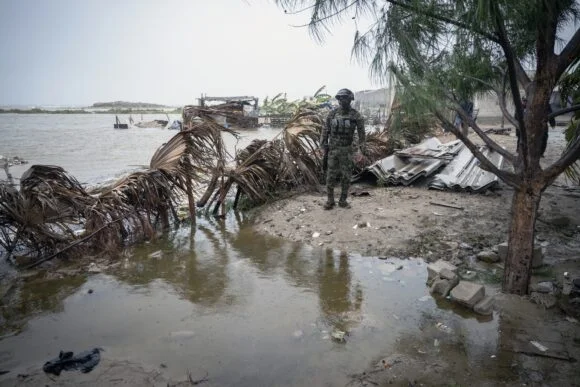
Forecasts indicate parts of the Great Plains and Midwest, including the Corn Belt, might receive as much as five inches (13 centimeters) of rain in the next five days. This volume of precipitation could pose serious challenges for agriculture in the Corn Belt, where crops are particularly vulnerable during critical growing seasons. How farmers manage these conditions could influence both local and national food supply chains. Hurricane Polo made landfall as a Category 2 storm overnight, with maximum sustained winds recorded at 110 mph (175 kph). Thankfully, preliminary reports indicate no fatalities and minimal damage in impacted coastal areas, as remarked by Baja California Sur Governor Victor Manuel Castro during a Tuesday press conference. However, the situation remains fluid.
Storm's Path and Potential for Additional Damage
The storm is circling back to make a second landfall in Guaymas, Sonora this morning. Predicted conditions include the storm weakening to a Category 1 status while still delivering substantial rainfall. This change in classification doesn’t lessen the risk, as the US National Hurricane Center forecasts possible rain accumulations of up to a foot (30 centimeters) along the coast. Some regions in southern and central Sonora expect up to eight inches, raising concerns about localized flooding and the potential for further mudslides. (And this is the part most people overlook: mudslides can be more deadly than the initial storm surge.) The combination of saturated soils and steep terrain makes this an especially hazardous situation.
Emergency Preparedness in Mexico
In preparation for these conditions, Mexico has stationed approximately 7,000 military personnel and has set up over 150 temporary shelters throughout Baja California Sur. Authorities are taking proactive measures to mitigate risk; they’ve restricted beach access around San José del Cabo, as hazardous surf conditions pose further dangers. Previous flooding and mudslide risks experienced in Guerrero and Michoacán highlight the region's vulnerability, underscoring the necessity for such precautions.
Implications for the Future
The scale of flooding and severe weather seen this year suggests that communities in the central U.S. may need to adapt more comprehensively to increasing frequencies of extreme weather. If you're working in this space, recognizing and planning for these patterns will be critical. This is more significant than it looks; the weather isn’t just an annual inconvenience — it’s a long-term trend that requires sustained attention. Policymakers, emergency responders, and the general public need to gear up for the possibility that these events could grow more severe and frequent.
Image caption: A member of the Mexican Navy is seen near a flooded area in Puerto San Carlos, Baja California Sur state, Mexico, on September 28, 2026. (Photo credit: Carl de Souza/AFP/Getty Images)
Topics Flood
Discussion
Sign in to join the discussion.